| Araria | Araria | 2,830 | 53.53% | Raniganj Vriksh Vatika forest reserve, migratory bird sightings. |
| Arwal | Arwal | 638 | 67.43% | Sone river sandbanks, offbeat peaceful riverside views. |
| Aurangabad | Aurangabad | 3,305 | 70.32% | Deo Sun Temple, 15th-century stone structural heritage. |
| Banka | Banka | 3,020 | 58.17% | Mandar Hill, site of Samudra Manthan (ocean churning) legends. |
| Begusarai | Begusarai | 1,918 | 63.87% | Kanwar Lake Bird Sanctuary, Asia's largest oxbow lake (Ramsar site). |
| Bhagalpur | Bhagalpur | 2,569 | 63.14% | Vikramashila Stupa ruins, Dolphin Sanctuary, Tussar silk weaving. |
| Bhojpur | Arrah | 2,395 | 70.47% | Aranya Devi Temple, legacy of 1857 hero Veer Kunwar Singh. |
| Buxar | Buxar | 1,703 | 70.14% | Battle of Buxar site (1764), Ramrekha Ghat, Katkauli memorial. |
| Darbhanga | Darbhanga | 2,279 | 58.07% | Darbhanga Royal Palaces, Chandradhari Museum, Ahilya Asthan. |
| East Champaran | Motihari | 3,968 | 55.79% | Kesaria Stupa (world's tallest Stupa), Gandhi Smarak Pillar. |
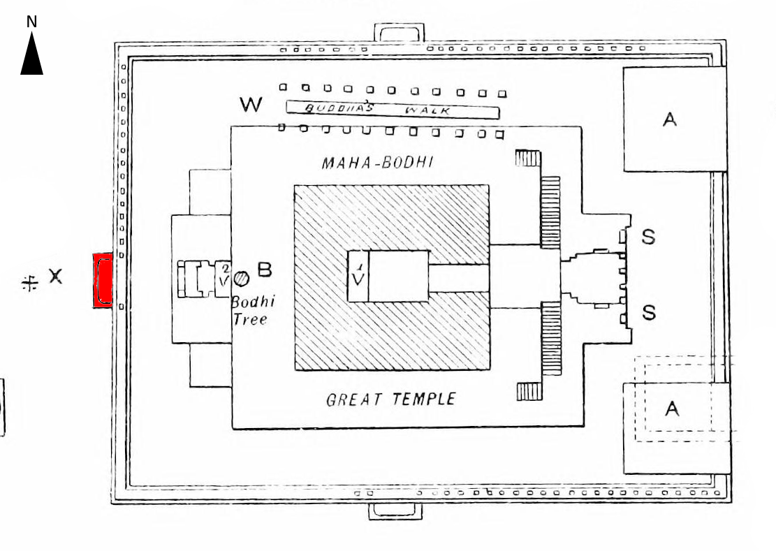
| Gaya | Gaya | 4,976 | 63.67% | Vishnupad Temple, Bodh Gaya Mahabodhi Stupa, Falgu river ghats. |
| Gopalganj | Gopalganj | 2,033 | 65.47% | Thawe Mandir (famous Durga temple), rich sugarcane fields. |
| Jamui | Jamui | 3,098 | 59.65% | Jain Mandir Dharamshala, Nagi-Nakti Dam Bird Sanctuary. |
| Jehanabad | Jehanabad | 931 | 66.80% | Barabar Caves, oldest rock-cut cave sanctuaries in India. |
| Kaimur | Bhabua | 3,332 | 69.34% | Mundeshwari Temple (oldest functional temple), Telhar Kund waterfall. |
| Katihar | Katihar | 3,057 | 52.24% | Gogabil Lake sanctuary, historic Gorakhnath temple. |
| Khagaria | Khagaria | 1,486 | 57.92% | Katyayani Mandir, confluence of seven major rivers. |
| Kishanganj | Kishanganj | 1,884 | 55.46% | Harishchandrapur Fort ruins, scenic tea estates of Bihar. |
| Lakhisarai | Lakhisarai | 1,228 | 59.58% | Ashokdham Temple, historic Indrapeeth archaeological ruins. |
| Madhepura | Madhepura | 1,788 | 52.25% | Singheshwar Sthan Shiva Temple, historic weekly cattle fair. |
| Madhubani | Madhubani | 3,501 | 58.62% | Madhubani Painting origins, Kapileshwar Temple. |
| Munger | Munger | 1,419 | 70.46% | Munger Fort, Bihar School of Yoga, hot springs of Bhimbandh. |
| Muzaffarpur | Muzaffarpur | 3,172 | 63.51% | Shahi Lychee orchards, Garibnath Mandir, local lac bangles. |
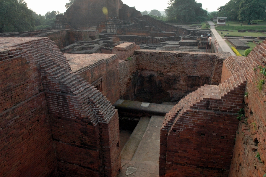
| Nalanda | Bihar Sharif | 2,355 | 64.43% | Nalanda University Ruins, Pawapuri Water Temple, Rajgir hills. |
| Nawada | Nawada | 2,494 | 59.76% | Kakolat Waterfall, scenic forest hills of Rajauli. |
| Patna | Patna | 3,202 | 70.68% | Patna Sahib Gurudwara, Kumhrar Maurya ruins, Bihar Museum. |
| Purnia | Purnia | 3,229 | 51.08% | Puran Devi Temple, historical colonial club, banana fibers. |
| Rohtas | Sasaram | 3,851 | 73.37% | Tomb of Sher Shah Suri, Rohtasgarh Fort, Tutla Bhawani falls. |
| Saharsa | Saharsa | 1,687 | 53.20% | Tara Asthan Mahishi temple, Matsyagandha Lake. |
| Samastipur | Samastipur | 2,904 | 61.86% | Vidyapati Nagar, Pusa Agricultural University research campus. |
| Saran | Chapra | 2,641 | 65.96% | Chirand Neolithic archaeological site, Sonpur Cattle Fair. |
| Sheikhpura | Sheikhpura | 689 | 63.86% | Giri Hinda hill temple, ancient rock structures. |
| Sheohar | Sheohar | 349 | 53.78% | Devangan Shiva Temple, smallest district by area in the state. |
| Sitamarhi | Sitamarhi | 2,294 | 52.05% | Janaki Mandir (Birthplace of Goddess Sita at Punaura Dham). |
| Siwan | Siwan | 2,219 | 69.45% | Don Stupa ruins, birthplace of first President Dr. Rajendra Prasad. |
| Supaul | Supaul | 2,425 | 57.67% | Dharahara Sun Temple, Kosi river project embankment trails. |
| Vaishali | Hajipur | 2,036 | 66.60% | Ashokan Pillar, World's First Republic ruins, Relic Stupa. |
| West Champaran | Bettiah | 5,228 | 55.70% | Valmiki Tiger Reserve, ashrams of Champaran, local wood crafts. |
1. Araria
Situated in the northern part of Purnia division, bordering Nepal. It has rich agricultural plains fed by the Kosi river canal systems.
- • Area: 2,830 km²
- • Key Crops: Paddy, Jute, Maize
- • Offbeat: Raniganj Vriksh Vatika
2. Arwal
Carved out of Jehanabad district to expedite development. Sits on the banks of the Sone river, known for its fine sand reserves.
- • Area: 638 km²
- • Key Crops: Wheat, Paddy, Pulses
- • Offbeat: Sone River Sunset Points
3. Aurangabad
The land of the Sun Temple. Located in the Magadh division, it features historical stone carvings and rich medieval forts.
- • Area: 3,305 km²
- • Key Crops: Paddy, Wheat, Mustard
- • Offbeat: Deo Sun Temple & Umga Hills
4. Banka
Lies in the southeastern region. Famous for Mandar Hill, which holds immense religious significance in Hindu cosmic mythology.
- • Area: 3,020 km²
- • Key Crops: Rice, Maize, Lentils
- • Offbeat: Mandar Hill & Papaharini Tank
5. Begusarai
The industrial capital of Bihar, situated on the northern bank of the Ganges. Home to India's premier fresh-water oxbow lake.
- • Area: 1,918 km²
- • Key Crops: Maize, Oilseeds, Wheat
- • Offbeat: Kanwar Lake Bird Sanctuary
6. Bhagalpur
Known globally as the Silk City due to its centuries-old Tussar silk weaving industries. Sits beside the Ganges delta system.
- • Area: 2,569 km²
- • Key Crops: Paddy, Maize, Silk Cocoons
- • Offbeat: Vikramashila Ruins & Dolphin Sanctuary
7. Bhojpur
Headquartered at Arrah. Famous for its rich Bhojpur linguistic heritage, historical temples, and agricultural yields.
- • Area: 2,395 km²
- • Key Crops: Wheat, Paddy, Sugarcane
- • Offbeat: Aranya Devi Mandir & Jagdishpur Fort
8. Buxar
The historic battleground where the British East India Company secured Diwani rights in 1764. Lined with scenic ghats.
- • Area: 1,703 km²
- • Key Crops: Paddy, Wheat, Pulses
- • Offbeat: Ramrekha Ghat & Katkauli Memorial
9. Darbhanga
The heart of Mithila culture. Renowned for its rich musical traditions, grand royal palaces, mango orchards, and ponds.
- • Area: 2,279 km²
- • Key Crops: Mango, Makhana (Foxnuts), Paddy
- • Offbeat: Darbhanga Fort & Shyama Kali Temple
10. East Champaran
Headquartered at Motihari. Celebrated for its revolutionary history and the world's tallest Buddhist stupa at Kesaria.
- • Area: 3,968 km²
- • Key Crops: Sugarcane, Paddy, Lentils
- • Offbeat: Kesaria Stupa & Gandhi Memorial
11. Gaya
The international spiritual capital. Renowned for Buddhist pilgrimage centers and Hindu Shraddha karma rituals along Falgu river.
- • Area: 4,976 km²
- • Key Crops: Paddy, Wheat, Til (Sesame)
- • Offbeat: Mahabodhi Temple & Dungeshwari Caves
12. Gopalganj
Located in the Saran division, it shares borders with Uttar Pradesh. Highly known for sugarcane processing and local temples.
- • Area: 2,033 km²
- • Key Crops: Sugarcane, Wheat, Mustard
- • Offbeat: Thawe Durga Temple
13. Jamui
Rich in minerals, forests, and hills. It is home to ancient Jain shrines, forest reserves, and the pristine Nagi Dam.
- • Area: 3,098 km²
- • Key Crops: Maize, Paddy, Pulses
- • Offbeat: Nagi-Nakti Bird Sanctuary & Lachhuar
14. Jehanabad
Located in the Magadh division. Famous for the oldest rock-cut caves in India, carved during the Mauryan period.
- • Area: 931 km²
- • Key Crops: Paddy, Wheat, Oilseeds
- • Offbeat: Barabar Hills & Lomas Rishi Cave
15. Kaimur
Headquartered at Bhabua. Famous for its rugged Kaimur hills, wildlife tracts, waterfalls, and the ancient Mundeshwari Temple.
- • Area: 3,332 km²
- • Key Crops: Paddy, Wheat, Lentils
- • Offbeat: Telhar Kund & Mundeshwari Temple
16. Katihar
Lies in eastern Bihar, featuring a major railway junction. Known for jute processing, marshy wetlands, and migratory routes.
- • Area: 3,057 km²
- • Key Crops: Jute, Maize, Paddy
- • Offbeat: Gogabil Lake Wetlands
17. Khagaria
Bounded by major rivers (Ganges, Gandak, Bagmati). Highly prone to seasonal changes, making it a rich alluvial belt.
- • Area: 1,486 km²
- • Key Crops: Maize, Wheat, Bananas
- • Offbeat: Katyayani Mandir (River Confluence)
18. Kishanganj
The only tea-producing district of Bihar, sharing borders with West Bengal and Nepal. Receives the highest rainfall in the state.
- • Area: 1,884 km²
- • Key Crops: Tea Leaves, Pineapple, Jute
- • Offbeat: Mahananda River banks & local Tea Gardens
19. Lakhisarai
Established around the historic Kiul river basin. Renowned for archaeological sites of the Pala dynasty and massive Shiva shrines.
- • Area: 1,228 km²
- • Key Crops: Pulses, Wheat, Paddy
- • Offbeat: Ashokdham Temple & Indrapeeth ruins
20. Madhepura
Part of the Kosi division. Rich in local folk histories, agro-processing mills, and the legendary Singheshwar temple complex.
- • Area: 1,788 km²
- • Key Crops: Paddy, Jute, Oilseeds
- • Offbeat: Singheshwar Sthan Shiva Temple
21. Madhubani
The homeland of the world-famous Madhubani art. Famous for its rich ponds, Sanskrit universities, and handloom fabrics.
- • Area: 3,501 km²
- • Key Crops: Makhana, Paddy, Mangoes
- • Offbeat: Saurath Sabha & Kapileshwar Temple
22. Munger
Sits on the bank of the Ganges. Globally famous for the Bihar School of Yoga, gun-making heritage, and warm mineral springs.
- • Area: 1,419 km²
- • Key Crops: Wheat, Maize, Pulses
- • Offbeat: Munger Fort & Bhimbandh Hot Springs
23. Muzaffarpur
The Lychee capital of India. Located on the bank of the Burhi Gandak river, it is highly prominent for trade and local craft works.
- • Area: 3,172 km²
- • Key Crops: Shahi Lychee, Paddy, Garlic
- • Offbeat: Garibnath Temple & local Lac factories
24. Nalanda
The intellectual center of ancient India, containing the UNESCO ruins of Nalanda University, hot springs of Rajgir, and Pawapuri.
- • Area: 2,355 km²
- • Key Crops: Potato, Onion, Paddy
- • Offbeat: Nalanda Ruins & Ghora Katora Lake
25. Nawada
Lies in southern Bihar on the border of Jharkhand. Known for scenic hills, waterfalls, and mineral deposits.
- • Area: 2,494 km²
- • Key Crops: Wheat, Paddy, Sugarcane
- • Offbeat: Kakolat Waterfall & Sekhodeora Ashram
26. Patna
The metropolitan capital and ancient site of Pataliputra. Center of politics, history, and transport corridors in Bihar.
- • Area: 3,202 km²
- • Key Crops: Wheat, Paddy, Pulses
- • Offbeat: Takht Patna Sahib & Kumhrar Ruins
27. Purnia
One of the oldest administrative districts in eastern India. Known for rich jute trade, historic colonial clubs, and temples.
- • Area: 3,229 km²
- • Key Crops: Jute, Maize, Banana
- • Offbeat: Puran Devi Temple & Jalalgarh Fort
28. Rohtas
Headquartered at Sasaram. Famous for the tomb of Sher Shah Suri, the massive Rohtasgarh hill fort, and waterfalls.
- • Area: 3,851 km²
- • Key Crops: Paddy, Wheat, Sesame
- • Offbeat: Sasaram Tomb & Rohtasgarh Fort Complex
29. Saharsa
Part of the Mithila cultural zone. Bounded by Kosi river basin, featuring deep cultural heritage and local lake parks.
- • Area: 1,687 km²
- • Key Crops: Paddy, Jute, Makhana
- • Offbeat: Tara Sthan temple (Mahishi)
30. Samastipur
Located on the bank of the Budhi Gandak. Famous for the historic Pusa Agricultural University and spiritual sites.
- • Area: 2,904 km²
- • Key Crops: Tobacco, Wheat, Turmeric
- • Offbeat: Vidyapati Nagar & Pusa Research Campus
31. Saran
Headquartered at Chapra. Home to Chirand, the first neolithic archaeological site in the Gangetic valley, and Sonepur fair.
- • Area: 2,641 km²
- • Key Crops: Potato, Wheat, Paddy
- • Offbeat: Chirand Archaeological Site
32. Sheikhpura
One of the smallest districts of Bihar. Dominated by rocky ridges, local stone quarrying, and old hill shrines.
- • Area: 689 km²
- • Key Crops: Paddy, Pulses, Wheat
- • Offbeat: Giri Hinda Hill & Sheikhpura Fort ruins
33. Sheohar
The smallest district in Bihar by area, carved out of Sitamarhi to streamline flood management and public policy.
- • Area: 349 km²
- • Key Crops: Paddy, Wheat, Maize
- • Offbeat: Devangan Shiva Temple
34. Sitamarhi
The sacred birthplace of Goddess Sita. Lined with historical temples and stepwells celebrating the Ramayana epoch.
- • Area: 2,294 km²
- • Key Crops: Paddy, Wheat, Sugarcane
- • Offbeat: Janaki Mandir (Punaura Dham)
35. Siwan
Located on the border of Uttar Pradesh. Birthplace of India's first President, Dr. Rajendra Prasad, and home to ancient stupas.
- • Area: 2,219 km²
- • Key Crops: Sugarcane, Wheat, Maize
- • Offbeat: Ziradei & Don Stupa Ruins
36. Supaul
Bounded by the Kosi River. Extremely fertile plains known for local agro-industrial projects and sun temples.
- • Area: 2,425 km²
- • Key Crops: Paddy, Jute, Wheat
- • Offbeat: Dharahara Sun Temple
37. Vaishali
Headquartered at Hajipur. Famous as the capital of the Licchavis, the world's first republic, and birthplace of Lord Mahavira.
- • Area: 2,036 km²
- • Key Crops: Banana, Paddy, Maize
- • Offbeat: Ashokan Lion Pillar & Relic Stupa
38. West Champaran
Headquartered at Bettiah. The largest district in Bihar, home to the Valmiki Tiger Reserve and dense sub-Himalayan forests.
- • Area: 5,228 km²
- • Key Crops: Paddy, Sugarcane, Jute
- • Offbeat: Valmiki Tiger Reserve & Someshwar Fort
Clarifications
Frequently Asked Questions
What is the spiritual significance of Bodh Gaya?
Bodh Gaya is the place where Siddhartha Gautama meditated under the Bodhi Tree and attained absolute enlightenment, becoming the Buddha. It is the most sacred pilgrimage site for Buddhists worldwide.
How can I travel between Patna, Nalanda, and Rajgir?
Patna, Nalanda, and Rajgir are located in close proximity (within 100-110 km of each other). You can easily travel between them via daily trains, local buses, or by hiring private taxis along NH-31.
What is the historical importance of Pataliputra?
Pataliputra (modern Patna) was the capital of several major Indian empires, including the Shishunaga, Nanda, Maurya, Shunga, and Gupta empires. It was the center of power and learning for the entire Indian subcontinent for centuries.
What is the significance of Chhath Puja?
Chhath Puja is an ancient Hindu Vedic festival dedicated to the Sun God (Surya) and his sister Chhathi Maiya. It is celebrated to thank Surya for sustaining life on earth. It is unique as it involves worshiping both the setting and rising sun along rivers.
Where is the tomb of Sher Shah Suri located?
The tomb of Sher Shah Suri is located in Sasaram town in Rohtas district. It is a stunning red sandstone mausoleum built in Indo-Islamic style, standing in the center of an artificial lake.
What is the significance of the Barabar Caves?
The Barabar Caves in Jehanabad district are the oldest surviving rock-cut caves in India, dating back to the Mauryan Empire (3rd century BCE). They feature highly polished internal granite surfaces and exceptional acoustic echoes.
What is the Cyclopean Wall of Rajgir?
The Cyclopean Wall is a 40 km long prehistoric stone wall that encircled ancient Rajgir (Rajgriha) to protect it from invaders. It is built using massive undressed stones and dates back to the pre-Mauryan era.
What is the specialty of Madhubani art?
Madhubani painting (or Mithila painting) is a traditional art form characterized by eye-catching geometrical patterns, double-line outlines, and natural organic pigments. It traditionally depicts nature, Hindu deities, and social events.
Where is Valmiki National Park located?
Valmiki National Park is located in the West Champaran district of Bihar, at the foothills of the Himalayas. It is the only national park and tiger reserve in Bihar, featuring diverse flora and fauna.
What is the best season to visit Bihar?
The ideal time to visit Bihar is during the winter season (October to March) when the weather is pleasant and temperatures range from 10°C to 25°C. This period is perfect for sightseeing across archaeological sites and participating in Chhath Puja or the Sonepur Cattle Fair.
What are the main rivers flowing through Bihar?
The Ganges is the primary river of Bihar, flowing from west to east and dividing the state into north and south regions. Major tributaries flowing from the north include the Gandak, Bagmati, Kamla, and Kosi. Main southern tributaries include the Sone, Punpun, and Karmanasa.
What are the primary regional languages of Bihar?
While Hindi and Urdu are the official state languages, the region is rich in local Bihari languages. The primary languages spoken are Maithili (which has official status in the Indian Constitution), Bhojpuri (predominant in western regions), and Magahi (spoken in the Magadh region).
What are the local government travel portals for Bihar?
The official tourism portal is maintained by the Bihar State Tourism Development Corporation at tourism.bihar.gov.in. State administrative portals are available at bihar.gov.in.