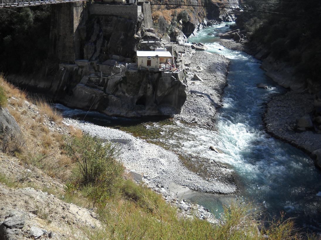
1. Hydro-Geomorphology, The Dhauliganga Confluence & Gorge Defile
Vishnuprayag is situated at an elevation of 1,372 metres (4,501 feet) in the northern upper reaches of Chamoli district, located 12 kilometres downhill from Joshimath and 34 kilometres south of Badrinath Dham. It is the premier, northernmost, and highest of the Panch Prayags, representing the first major river convergence in the journey of the Alaknanda toward the Gangetic plains.
The confluence is geographically dramatic: the Alaknanda River, having carved its way through the sheer Badrinath canyon, crashes into the Dhauliganga (meaning 'White River'), which hurtles down from the trans-Himalayan glaciated valleys of Niti Pass and the Raunthi/Rishiganga gorges. Because both streams carry immense velocity and glacial silt, their collision within this narrow, sheer-walled granite amphitheater produces a deafening hydraulic roar that echoes through the canyon.
A dramatic suspension footbridge spans the churning chasm, offering dizzying, bird's-eye views directly into the frothing vortex where the two glacial giants merge.
Vishnuprayag is the very first and highest of the five sacred river confluences of the Himalayas, situated at 1,372 metres. Here, the holy Alaknanda (descending from Satopanth glacier through Mana and Badrinath) receives its very first major glacial tributary: the roaring, silt-heavy Dhauliganga (originating from the trans-Himalayan heights of Niti Pass).
2. Vedic Antiquity: Sage Narada's Penance & Lord Vishnu's Epiphany
The theological sanctity of Vishnuprayag is detailed in the Kedar Khanda of the Skanda Purana. According to legend, Sage Narada, seeking ultimate spiritual enlightenment and detachment from earthly illusions, selected this desolate granite ravine for intense tapasya. Standing on a solitary rock amidst the freezing glacial spray, Narada performed thousands of years of penance dedicated to Lord Vishnu.
Pleased by his unshakeable devotion, Lord Vishnu manifested before the sage in his radiant four-armed cosmic form (Chaturbhuja), blessing the confluence with his divine name and declaring that anyone who bathes at this sacred spot with a pure heart would attain Vaikuntha (the spiritual abode of Vishnu).
Pilgrims en route to Badrinath traditionally halt here to perform ablutions at the octagonal stone Vishnu Kund, offering prayers to the deity before ascending into the higher Himalayan sanctuary of Badri Vishal.

3. The 1889 Ahilyabai Holkar Temple & Historic Vishnu Kund
Standing proudly on the rocky spur above the confluence is the historic Vishnu Temple. In 1889, the temple structure was comprehensively reconstructed by the visionary queen-ruler of the Maratha Malwa kingdom, Maharani Ahilyabai Holkar of Indore, whose legendary philanthropic rebuilding of pilgrimage shrines reshaped sacred geography across India.
The temple is constructed of local dressed gray granite, designed in classical Nagara style with an octagonal mandapa and a stone shikhara that resists harsh Himalayan winter weather. Inside the sanctum stands an ancient black stone idol of Lord Vishnu in serene contemplation. Adjacent to the shrine lies the sacred octagonal stone bathing cistern known as Vishnu Kund.
The temple complex is maintained by local priest-families, whose daily morning and evening aartis resonate with the ancient chanting of Vedic Vishnu Sahasranama against the roar of the water.
4. Gateway to the Niti Valley & The Kagbhusandi Tal Trail
Beyond its pilgrim importance, Vishnuprayag is the strategic geographical gateway to the trans-Himalayan Niti Valley and the remote Indo-Tibetan borderlands. Crossing the bridge over the Dhauliganga leads onto the motorable border highway that ascends past Tapovan, the Dhauliganga hot sulfur springs, Malari, and the high cold-desert plateau of Niti village.
The gorge flanking Vishnuprayag also serves as the traditional trekking approach for the legendary high-altitude emerald lake of Kagbhusandi Tal (elevation 5,280m), tucked beneath the peaks of Hathi Parbat. According to the Ramacharitmanas, the divine crow-sage Bhusandi meditated at this pristine glacial lake, narrating the story of Lord Rama to Garuda.
The sheer canyon walls surrounding the confluence are cloaked in wild cypress and juniper, where Himalayan tahr and mountain eagles can often be spotted on upper rock ledges.

The descent from the main Badrinath highway to the Vishnu Kund bathing ghat involves negotiating over 300 steep, narrow stone steps down a near-vertical cliff gorge. The colliding water currents generate immense spray and deafening noise. Bathing directly in the mid-river torrent is strictly prohibited; pilgrims must remain inside the protective stone pool enclosure.
5. Travel Logistics from Joshimath, Badrinath Route & Seasons
Vishnuprayag is located along National Highway 7, exactly 12 kilometres north of Joshimath on the road to Badrinath. The highway runs along the upper cliff ledge, where a roadside parking area and tea stalls are situated. From the roadside, visitors descend over 300 stone steps to reach the temple and confluence ghat.
Because of its location on the primary Badrinath pilgrimage corridor, public transport, shared jeeps, and private taxis between Joshimath and Badrinath pass Vishnuprayag continuously throughout the Char Dham season (May to November). Travel time from Joshimath is approximately 25 to 30 minutes.
The ideal time to visit Vishnuprayag is from May to June and September to November. Autumn (September to November) provides the most breathtaking vistas, with clear skies, crisp alpine air (10°C to 18°C), and water at its most dramatic. In winter (December to April), heavy snow falls across the upper canyon, but the confluence remains unfrozen due to the tremendous water velocity.
Curated Field Dossier & Offline Google Maps Pin Pack
Bypass tourist traps with verified local logistics, exact parking coordinates, and field-tested routes.
- ✓Exact GPS Pin Pack: Unmarked parking spots, best dawn photography vantage points, and hidden trailheads.
- ✓Crowd-Avoidance Timing Matrix: Exact hour-by-hour windows to explore with zero tourist chaos.
- ✓Vetted Local Dhabas: 100% authentic, hygiene-checked regional food stops not on commercial maps.
- ✓Scam & Overcharge Shield: Verified taxi rates, auto fares, and local guide fee guidelines.
🛡️ Personally curated by PK Gupta & the Hidden Routes research desk. Delivered directly to your Email & WhatsApp within 4–8 hours.
Frequently Asked Questions
What two rivers meet at Vishnuprayag?
Vishnuprayag is the sacred confluence of the Alaknanda River (flowing from Satopanth and Badrinath) and the Dhauliganga River (flowing from Niti Pass).
Why is Vishnuprayag called the first of the Panch Prayags?
It is the first and highest of the five confluences in geographical and hydrological order, situated at an altitude of 1,372 metres, where the Alaknanda receives its very first major glacial tributary.
Who rebuilt the historic temple at Vishnuprayag?
The historic stone Vishnu temple was rebuilt in 1889 by Maharani Ahilyabai Holkar of Indore, the legendary queen renowned for restoring major pilgrimage temples across India.
How can one reach the confluence ghat from the main highway?
Visitors must descend a well-constructed flight of approximately 300 stone steps from the roadside parking terrace down to the riverbed and temple platform, taking about 15 minutes to descend and 25 minutes to climb back up.
How far is Vishnuprayag from Joshimath and Badrinath?
Vishnuprayag is located 12 kilometres north of Joshimath (about 25 minutes by road) and 34 kilometres south of Badrinath Dham (about 1 to 1.5 hours by road).
Connecting Himalayan Routes & Circuits
Explore authoritative regional itineraries, sacred circuits, and connecting valleys across Uttarakhand's Garhwal and Kumaon Himalayas: