Orographic Splendor: The Crown of the Wayanad Plateau
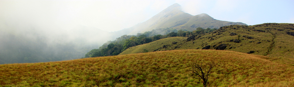
Soaring to a majestic altitude of 2,100 meters (6,890 feet) above sea level in the southern plateau of Wayanad district, Chembra Peak is the highest mountain summit in Wayanad and one of the loftiest peaks in the Western Ghats south of the Nilgiri massif. Flanked by the rolling tea-clad slopes of Meppadi and the contiguous forest reserves of the Nilgiris and Malabar Wildlife Sanctuary, Chembra stands as an imposing granite fortress crowned by mist.
The mountain belongs to a distinctive geological landform known as a 'shola-grassland mosaic'. The lower and mid-slopes are carpeted in velvety rolling montane grasslands, while the deep, sheltered ravines harbor dense, stunted evergreen rainforests (sholas) rich in mosses, tree ferns, and endemic epiphytic orchids. This unique vertical stratification creates microclimates that shift within hundreds of meters of elevation.
Ascending Chembra offers a sensory journey through multiple ecological zones. What begins in manicured emerald tea plantations soon transitions into wild grassland trails where mountain breezes whistle through tussock grasses, carrying the crisp, thin scents of pine needles and damp earth. On clear mornings, the summit ridges afford sweeping 360-degree vistas stretching across the entire Wayanad plateau, the distant blue silhouettes of the Nilgiri mountains in Tamil Nadu, and the Kozhikode coastal plains to the west.
The Mountain Ascent: From Tea Gardens to Hridaya Saras
The trek to Chembra Peak commences at the Vana Samrakshana Samithi (VSS) forest checkpost nestled amidst the high tea gardens of Meppadi, approximately 1,000 meters above sea level. From the trailhead, hikers embark on a moderately demanding 4.5-kilometer uphill climb covering an elevation gain of over 500 meters to reach the legendary Heart Lake.
The initial section of the trail winds steeply through rocky dirt paths bordered by tea bushes and silver oak trees, soon emerging onto open grassland slopes. Here, the trail steepens significantly, requiring hikers to scramble over exposed laterite boulders and navigate narrow grassy ridges. Wooden trail markers and designated resting gazebos provide welcome breathers where trekkers can pause to take in the unfolding mountain panoramas.
After approximately two hours of steady climbing, the trail crests an undulating grassy plateau, and suddenly, the breathtaking spectacle of Hridaya Saras reveals itself. Nestled in a natural mountain amphitheater, the tranquil lake reflects the azure sky and drifting white clouds in its mirror-like waters. Its heart-shaped outline is so geometrically crisp and natural that it seems sculpted by an artist's hand, inspiring wonder in every hiker who reaches its grassy shores.
Ecological Fragility: Shola Habitats and Endemic Wildlife
The shola-grassland ecosystem of Chembra Peak is an irreplaceable hydrological and ecological treasure. Acting as a giant natural sponge, the high-altitude peat soils and mossy shola forests absorb intense monsoon downpours, slowly releasing the filtered rainwater throughout the dry months to feed the Chaliyar and Kabini river catchments that sustain millions of people downstream.
These isolated sky islands also harbor extraordinary biological endemism. Botanists have recorded rare high-altitude flora, including several species of wild balsams (Impatiens), carnivorous sundews (Drosera), and the iconic Neelakurinji (Strobilanthes kunthiana), which blooms once every twelve years, turning the rolling mountain slopes into a sea of purplish-blue.
The forest pockets around the base of Chembra serve as vital transit corridors for Asian elephants moving between the Wayanad and Nilgiri reserves. Birdwatchers frequently spot rare Western Ghats endemics, such as the Nilgiri pipit foraging in the grasslands, the striking white-bellied treepie, the Malabar whistling thrush, and the elusive Nilgiri wood pigeon roosting in shaded shola ravines.
Situated at an elevation of 1,500 meters along the windswept shola ridge, Hridaya Saras (literally 'Heart Lake' in Sanskrit) is an extraordinary natural alpine tarn formed in the precise anatomical contour of a heart. Local indigenous folklore attributes perennial divine qualities to the water body, which has never been known to dry up even during severe pre-monsoon summer droughts.
Mountain Lore: Kurichiya Legends and Colonial Tea Plantations
Chembra Peak has been venerated for centuries by the indigenous Kurichiya and Paniya tribes of Wayanad. The Kurichiyas—renowned archers who fought valiantly alongside Kerala Varma Pazhassi Raja against British colonial forces in the Wayanad guerrilla wars of 1800–1805—considered the mountain a sacred redoubt and spiritual sanctuary where ancestral deities dwelt in the cloud-capped crests.
In the late 19th century, British planters recognized the ideal climatic conditions of the Chembra foothills, establishing sprawling tea estates along its lower ridges. Colonial bungalows built of local granite and teakwood still dot the emerald hills of Meppadi, surrounded by vibrant rose gardens and tea processing factories whose chimney plumes drift into the morning mist.
Visiting a traditional tea factory in Meppadi provides a fascinating insight into orthodox tea manufacturing, where hand-plucked green leaves from the slopes of Chembra are withered, rolled, oxidized, and dried into aromatic black and green teas that carry the distinctive brisk character of high-altitude Wayanad terroir.

Trekking Logistics, Entry Timings and Essential Regulations
Chembra Peak is located 17 kilometers south of Kalpetta, the district headquarters of Wayanad, and 82 kilometers east of Kozhikode Railway Station. The nearest airport is Calicut International Airport (CCJ) at Karipur (95 km). Taxis and auto-rickshaws easily reach the Meppadi forest base from Kalpetta, Sultan Bathery, or Vythiri.
Trekking is strictly regulated by the Kerala Forest Department to protect the fragile alpine environment. Trekking permits are issued only at the VSS counter near the trailhead starting at 7:00 AM. A fixed fee of approximately Rs. 750 (for a group of up to 10 Indian citizens) or Rs. 1,500 (for foreign visitors) includes a mandatory accompanying local forest guide.
Trekkers must start early to beat the midday heat and avoid afternoon mountain mist. Carry at least two liters of water in reusable non-plastic bottles, wear sturdy hiking boots with aggressive tread, apply sunscreen and a sun hat, and carry a lightweight rain jacket even during winter. Single-use plastic bottles, plastic wrappers, alcohol, and smoking are strictly confiscated at the forest entry checkpoint.
To prevent alpine soil degradation, the South Wayanad Forest Development Agency (VSS) caps daily trekking permits to 200 persons on a strict first-come, first-served basis starting at 7:00 AM at the Meppadi checkpost. Trekking beyond the Heart Lake to the actual summit ridge is prohibited to safeguard fragile shola ecology and wild elephant corridors.
Curated Field Dossier & Offline Google Maps Pin Pack
Bypass tourist traps with verified local logistics, exact parking coordinates, and field-tested routes.
- ✓Exact GPS Pin Pack: Unmarked parking spots, best dawn photography vantage points, and hidden trailheads.
- ✓Crowd-Avoidance Timing Matrix: Exact hour-by-hour windows to explore with zero tourist chaos.
- ✓Vetted Local Dhabas: 100% authentic, hygiene-checked regional food stops not on commercial maps.
- ✓Scam & Overcharge Shield: Verified taxi rates, auto fares, and local guide fee guidelines.
🛡️ Personally curated by PK Gupta & the Hidden Routes research desk. Delivered directly to your Email & WhatsApp within 4–8 hours.
Frequently Asked Questions
What is the heart-shaped lake on Chembra Peak?
The heart-shaped lake is called Hridaya Saras. It is a natural, perennial freshwater alpine lake situated at an elevation of about 1,500 meters along the trekking route of Chembra Peak in Wayanad, famous for never drying up.
How long and difficult is the Chembra Peak trek?
The trek to the Heart Lake is moderately challenging, covering approximately 4.5 km uphill (9 km round trip) and taking about 3 to 4 hours of hiking. It involves steep, rocky grassland climbs with an elevation gain of around 500 meters.
Can trekkers go all the way to the top of Chembra Peak?
No, trekking beyond the Heart Lake to the actual summit at 2,100 meters is currently prohibited by the Kerala Forest Department to preserve the fragile high-altitude shola ecology and protect wild elephant corridors.
How do I get a trekking permit for Chembra Peak?
Permits are issued on the spot by the South Wayanad Forest Development Agency (VSS) office near Meppadi starting at 7:00 AM. Only 200 permits are issued per day on a first-come, first-served basis, so arriving early is essential.
What is the best time of year to trek Chembra Peak?
The best trekking season is from September to February when the post-monsoon grasslands are lush green, the weather is cool and pleasant, and skies are clear for expansive valley views.
Connecting Kerala Routes & Nearby Highlights
Seamlessly link your journey through Wayanad with these handpicked cultural circuits, coastal trails, and mountain road gateways across Kerala: