Coastal Geography: The Vamsadhara Estuary and Kalinga Maritime Glory
Located in Gara mandal of northernmost Srikakulam district, Kalingapatnam is an enchanting coastal destination where geography and ancient history converge. The town is situated on a low sandy peninsula bounded on the south by the sacred Vamsadhara River and on the east by the sweeping waters of the Bay of Bengal.
In ancient historical chronicles dating back over two millennia, Kalingapatnam was celebrated as the primary oceanic gateway of the Kalinga Empire. Roman gold coins, ancient pottery shards, and maritime artifacts excavated along the estuary confirm extensive direct maritime trade with the Mediterranean world and the empires of Southeast Asia (Suvarnabhumi).
The beach itself is vast, open, and remarkably unspoiled. Fine golden sands stretch for kilometers without commercial clutter, flanked by gentle rolling surf and coastal casuarina shelterbelts that whisper under steady sea breezes, making it one of the most serene offbeat coastal getaways in northern Andhra Pradesh.
Colonial Resurgence: The British East India Company Trading Post
Following centuries of medieval transition, Kalingapatnam experienced a dramatic commercial revival during the British colonial era in the 18th and 19th centuries. British administrators recognized the natural advantages of the Vamsadhara estuary, establishing Kalingapatnam as a major customs port and trading hub.
Large commercial vessels from Europe, Singapore, and Burma anchored in the roadstead to load valuable cargoes of fine handloom textiles, rice, oilseeds, and coir. British merchant houses, customs houses, and sprawling godowns were erected along the riverfront, transforming the ancient Kalinga capital into a bustling colonial port town.
Though modern shipping operations eventually shifted south to the deepwater harbors of Visakhapatnam, Bheemili, and Kakinada, the architectural footprints of this colonial era remain visible in the town's dignified heritage bungalows and maritime structures.
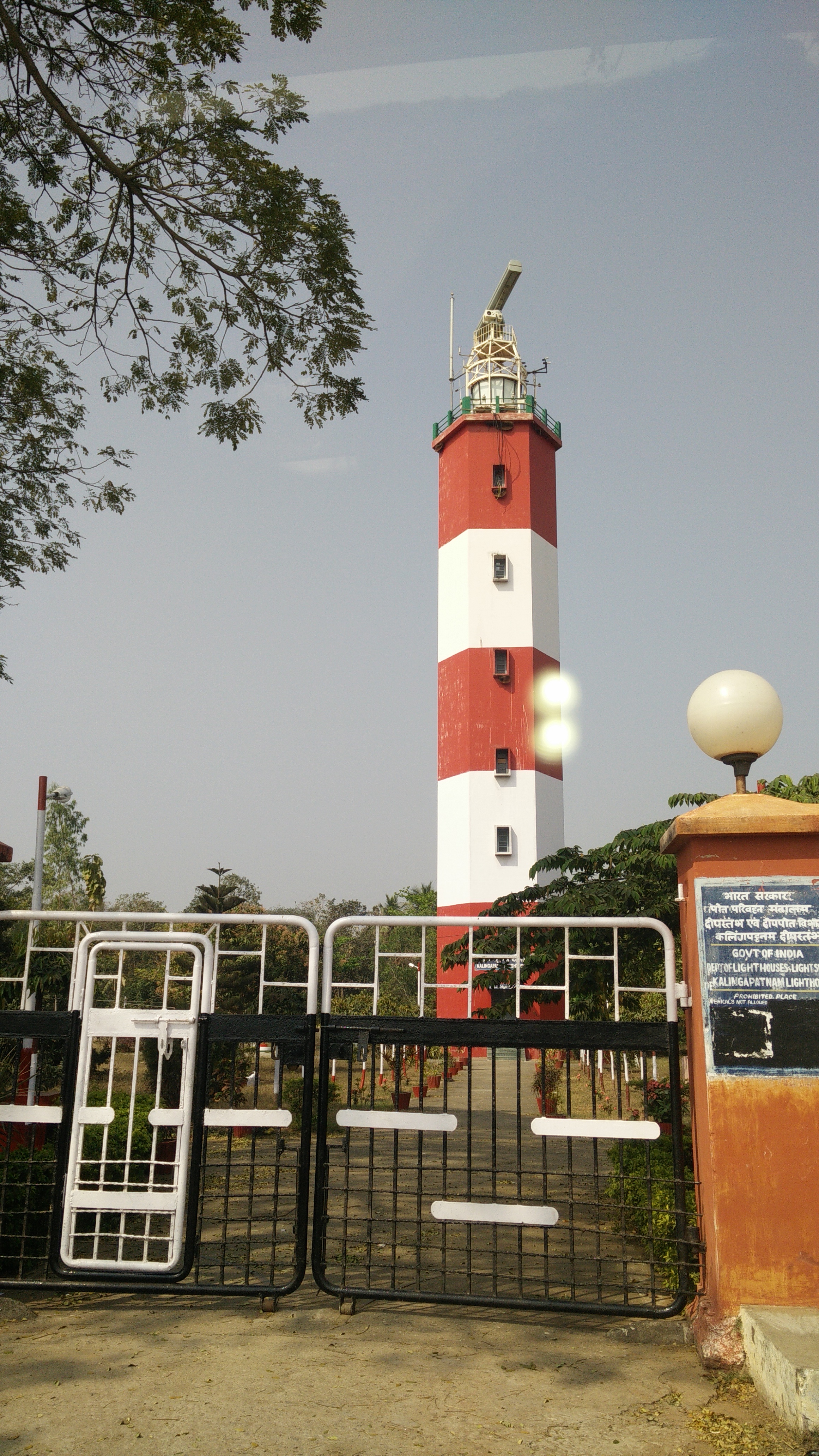
The 1884 Lighthouse: Architectural Landmark and Panoramic Views
The defining architectural wonder of Kalingapatnam is the historic British Colonial Lighthouse, constructed in 1884 to safeguard international merchant vessels navigating the treacherous sandbanks of the Vamsadhara river mouth. Standing proudly atop a low coastal dune, the lighthouse features a massive 22-meter-tall circular stone masonry tower painted in classic red and white horizontal bands.
The lighthouse operates an advanced optical revolving lens system that emits three powerful white flashes every 20 seconds, projecting a brilliant navigational beacon visible to ships up to 30 nautical miles out at sea.
Visitors can climb the spiral internal staircase of the lighthouse during visiting hours (typically 3:00 PM to 5:00 PM) to reach the open viewing gallery beneath the lantern dome. The summit rewards climbers with staggering 360-degree panoramic vistas: gazing inland reveals the broad, meandering blue ribbon of the Vamsadhara River threading through emerald paddy fields, while looking seaward unveils the endless, shimmering horizon of the Bay of Bengal.
In ancient antiquity, Kalingapatnam served as the principal maritime seaport and capital of the mighty Kalinga Empire. From this natural harbor, ancient Indian merchant armadas (Sadhavas) embarked on transatlantic maritime expeditions across the Bay of Bengal to Java, Sumatra, Bali, Sri Lanka, and Cambodia, exporting fine textiles, spices, and disseminating Indian cultural traditions.
The Seaside Promenade: Relaxation, Casuarina Groves, and Sunsets
The Andhra Pradesh Tourism Development Corporation has developed a scenic beachfront promenade at Kalingapatnam, featuring shaded gazebos, stone-paved walking pathways, and landscaped gardens that offer peaceful vantage points to observe the rhythmic rolling of ocean breakers.
The beach is renowned for its gentle slope and wide expanse of firm, compacted sand during low tide, making it ideal for barefoot walks, beachcombing for exotic shells, and enjoying scenic coastal photography. Small seaside stalls near the lighthouse offer fresh tender coconut water, roasted corn, and local sweet snacks.
A unique local geographical treat is witnessing both sunrise over the Bay of Bengal and the serene reflection of dusk colors over the calm waters of the Vamsadhara River, offering photographers two distinct lighting spectacles within a 500-meter radius.

Transit Gateways, Road Logistics, and Regional Connectivity
Kalingapatnam is located 25 km east of Srikakulam city. The nearest major railway station is Srikakulam Road (CHE) in Amadalavalasa (32 km), located on the Howrah-Chennai mainline, serviced by dozens of daily superfast express trains connecting to Visakhapatnam, Kolkata, Chennai, and Hyderabad.
Visakhapatnam International Airport (VTZ) is located 125 km to the southwest (approximately 2.5 to 3 hours of driving via the smooth, multi-lane National Highway 16).
From Srikakulam city, smooth state highways pass through fertile agrarian landscapes and coconut groves to reach Kalingapatnam. APSRTC operates regular buses between Srikakulam central bus station and Kalingapatnam every 30 minutes. Taxis and auto-rickshaws can be easily hired in Srikakulam for comfortable half-day excursions.
The sandbar spit where the broad Vamsadhara River empties into the Bay of Bengal features strong underwater currents and shifting silt channels, particularly during high tide. Swimming near the river mouth is strictly discouraged. Stick to the shallow wave breaks directly in front of the main beach promenade.
Regional Heritage Circuits and Environmental Ethics
A trip to Kalingapatnam pairs seamlessly with nearby world-class heritage attractions in Srikakulam district. Located just 18 km to the west lies the renowned Arasavalli Sun Temple (Sri Suryanarayana Swamy Temple), one of the oldest and most celebrated solar shrines in India dating to the 7th-century Kalinga dynasty.
Also nearby is the historic Sri Kurmam Temple (22 km), the world's only classical temple dedicated to the Kurma (tortoise) second avatar of Lord Vishnu, celebrated for its unique Kalinga-Dravidian architecture and sacred tortoise conservation sanctuary.
Visitors to Kalingapatnam must maintain strict environmental decorum. Discarding plastic bottles, wrappers, or food waste on the beach dunes is strictly discouraged. Respect the traditional fishing communities operating along the sandspit and leave this historic Kalinga coastline pristine for future generations.
Curated Field Dossier & Offline Google Maps Pin Pack
Bypass tourist traps with verified local logistics, exact parking coordinates, and field-tested routes.
- ✓Exact GPS Pin Pack: Unmarked parking spots, best dawn photography vantage points, and hidden trailheads.
- ✓Crowd-Avoidance Timing Matrix: Exact hour-by-hour windows to explore with zero tourist chaos.
- ✓Vetted Local Dhabas: 100% authentic, hygiene-checked regional food stops not on commercial maps.
- ✓Scam & Overcharge Shield: Verified taxi rates, auto fares, and local guide fee guidelines.
🛡️ Personally curated by PK Gupta & the Hidden Routes research desk. Delivered directly to your Email & WhatsApp within 4–8 hours.
Frequently Asked Questions
Field-verified practical and cultural answers for planning your expedition to Kalingapatnam Beach & Colonial Lighthouse:
Connecting Andhra Routes
Continue your journey across the Eastern Ghats, Godavari river deltas, Bay of Bengal coastline, and sacred pilgrimage shrines: